My interest in the Civil War probably began when I was a child. I remember overhearing conversations among my southern relatives, laced with sentiments more appropriate to an antebellum age. Thus, an empathy for the Southern cause was effortlessly inculcated in me. My northern grandmother kept a large volume of battle scenes reprinted from Frank Leslie’s Illustrated Newspaper. Captivated by its depictions of soldiers, drummer boys, colorful flags with fascinating designs, exploding shells and the exotic names: Chickahominy, Seven Pines, the Angle, the Crater, Look Out Mountain, the Hornet’s Nest and The Wilderness, I wiled away many a summer’s hour, never tiring of the cut and thrust of men in blue and grey. Then too, in a chest nearby, there was the uniform my Father wore while attending the Staunton Military Academy. The stuff of dreams.
SHILOH:
Nestled against the Tennessee River, Shiloh Battlefield, also known as the Battle of Pittsburg Landing, is canopied by old trees that cast long shadows over its lush undergrowth, canon and monuments. The gloom seems permeated with hidden spirits and is imbued with a stillness that belies the violence that took place 151 years ago on 6-7 April, 1862.
At the time of the battle, some 400 people lived on the plateau above the river. The location of their small farms was naturally haphazard, determined by swamps, stands of trees and a maze of streams etching muddy channels to the Tennessee. The roads curved every which way. Today it is impossible for a first time visitor, even with a map, to know where they are in relation to the battle’s ebb and flow.

A contemporary map of Shiloh Battleground.
I visited Shiloh with Japanese percussionist Mika Yoshida, now Mika Stoltzman. We gave up trying to understand where we were in relation to the action and simply followed the curving roads through one woodland vista to the next. I cannot imagine what Mika was thinking. I doubt she’d ever been on a Civil War battlefield and was certain she knew nothing about Shiloh. No sounds carried in the heavy southern air, not from other visitors, not even from birds. Shiloh reminded me of a Japanese temple garden. A serious place encouraging serious contemplation. The two day battle mustered almost 24,000 casualties. A small log cabin church around which fierce fighting took place, lent its name to the conflict, in Hebrew, Shiloh means, Place of Peace. As we left the park, Mika paused and quietly said, “This is a sad place.”
Shiloh was the first major engagement of the Civil War and more than 4,000 acres are protected today by the National Park Service. It was Grant’s first claim to fame, but his claim was and is disputed by most everyone except Grant himself. Both he and his lifetime military colleague Sherman were told of lurking rebels and the messengers were sumarily dismissed. When an Ohio colonel warned Sherman that an attack was imminent, the general said, “Take your damned regiment back to Ohio. There is no enemy nearer than Corinth.” ( Corinth, Mississippi, lies 25 miles south of Shiloh.) The enemy was in the nearby woods waiting for the order to charge. To say the Union was caught off guard would be true, but an understatement of epic proportions.
Years later as I looked through some old battle ground photographs, I recalled Mika’s comment. Fredericksburg, Manassas, The Wilderness, Chancellorsville, Lookout Mountain and Antietam are battlefields I’ve visited. Each is unique in size, topography, consequences and, as Mika had recognized at Shiloh, aura. One consequence of Shiloh was the inspiration it provided William Shakespeare Hays to write The Drummer Boy of Shiloh, a song that sold a million copies in sheet music and influenced imitators who quickly created their own “Drummer Boy”.
GETTYSBURG:
During my high school years, I lived not far from Gettysburg, Pennsylvania. The commercial development and irreverent, tourist driven kitsch of today had not yet appeared. That began a few years later when the battle’s 100 year anniversary focused the public’s attention on the significant events that had occured when Gettysburg was a quaint rural hamlet. Occasionally I’d visit the battlefield’s highlights: Cemetery Ridge, Spangler’s Spring, Culp’s Hill, Little Round Top and Devils Den. One day I hunkered down in the Den and tried to imagine Longstreet’s attempt to envelop Meade’s left.
When visiting the stone wall on Cemetery Ridge, one must abandon automobiles and walk the ground. Otherwise the impact of what happened there cannot be appreciated. One must view the ridge from below, from the perspective of the men who had to walk three quarters of a mile without cover, half that distance up hill to a wall behind which lay an enemy fully prepared to meet them. From this perspective, the will and courage of Lee’s men can be understood. Considering Lee’s order, one Confederate officer opined, “It’s murder.”
And it was. On 3 July, 1862, 12,500 men formed in lines a mile long. When their so called charge was over, they had suffered more than 6,000 casualties. This was the Confederate high water mark. Though Meade allowed Lee to remove his wounded army across the Potomac River into northern Virginia, the South never fully recovered. Four months later President Lincoln arrived and read his Gettysburg Address.
ANDIETUM:ANTIEDUM
Indian Deed
Israel Friend in 1727 secured a deed from the Indian Chiefs of the Five Nations. Beginning “at the mouth of Andietum Creek thence up the Potomack River 200 shots as fur as an arrow can be slung out of the bow” thence “100 shoots right back from the river” then “squared till it interceeds with the creek”.
-Maryland State Roads Commission Plaque.
Farther west and south in Maryland, just a few miles from West Virginia, the land smooths out somewhat. Here, beyond the Allegany Mountains, there are fewer outcroppings of limestone monoliths like those at Devil’s Den and streams begin to flow westward towards the Ohio River, the Mississippi and ultimately the Gulf of Mexico. To me, a Baltimorian, western Maryland feels remote, even hidden. Sharpsburg has few neighbors and a visit to near by Shepherstown, only confirms the sense of isolation.
The battle of Antietam or Sharpsburg as Confederates prefer to call it, is more easily grasped then its eastern and more famous Pennsylvanian rival. The entire conflict took place on one day, 17 September,1862. The battle began at Miller’s Cornfield, migrated in a southerly direction to the Sunken Road and thence to the struggle for Burnside’s Bridge, a distance if approximately three miles. Today, near the center of the field, there’s an observation tower, allowing visitors to see much of the ground where the major engagements took place.
At first, Antietam Battlefield looks properly rural and benign as if it should be hosting a soft ball game and families with Frisbee catching dogs. The paved two lane Hagerstown Turnpike takes one up the western length of the battlefield, except for the bridge at its southern end, pass the National Park Service Visitors Center, the Dunker Church and the Cornfield. The uninformed might think the visitor’s center a rest stop, and Stonewall Jackson’s position worth a casual, “Oh look, an old church”. If noticed, the Cornfield wouldn’t provoke a comment.
McClellan had arrived with a two to one advantage over Lee. Yet technically, the battle ended in a draw. President Lincoln had cashiered Meade after Gettysburg for dawdling while Lee escaped and Major Gen. John Pope after 2nd Manassas a month later. He had brought McClellan back and given him everything he asked for, an enormous army, outfitted to the nines. Even so, he sat on his caution while the Union’s nemisis limped back across the Potomac, mauled, but still alive and dangerous.
Lincoln had every right to be pissed. Never the less the Confederates had been first to leave the field and that was close enough to a victory to allow him to issue his Emancipation Proclamation.

A beautiful field in Western Maryland with the Allegany Mountains providing a gentle backdrop. This is Antietam Battlefield. The Cornfield on the left was where the Bloodiest day of the Civil War began. Photo, R.E.
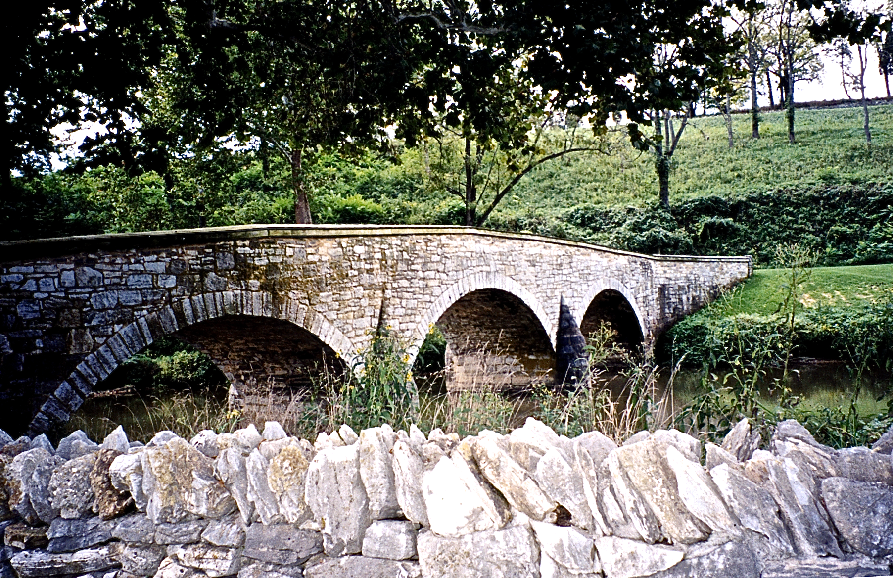
Burnside’s Bridge crossing Antietam Creek. Little has changed since the Battle of Antietam or Sharpsburg, 17 September 1862. Photo, R.E.

Burnside’s Bridge immediately after the Battle.

The Muffled Drums Sad Roll Has Beat
The Soldiers Last Tattoo.
Suggested reading:
Foote, Shelby; Stars in Their Courses, The Gettysburg Campaign; Modern Library Edition, New York, 1994.
McPherson, James M.; Battle Cry of Freedom, The Civil War Era; Oxford University Press, New York, 1988.
Sears, Stephen W.; Landscape Turned Red, The Battle of Antietam, Houghton Mifflin Company, Boston, New York, 1989.
Sword, Wiley; Shiloh: Bloody April, Morningside House Inc. Dayton, Ohio, 1988.

Brad Clark
November 10, 2013 at 4:10 pm
Thanks for the very interesting post.
Mika Stoltzman
November 17, 2013 at 3:15 pm
wow! I am remembering about it! Thank you for my name on this.It is great memory!!!